 It's been a while since last update, but here it is: version 0.2.6
So, what's new? Quite a bit actually! here's a short list:
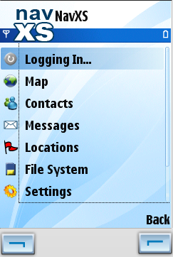
- Ta-da! A new main menu. Here a screenshot of how it looks on a Nokia. Hopefully it is easier to get around and find the right things now (let us know if it isn't).
- NavXS elevation map tiles are supported (see previous post).
- Users of the non-GPS editions (basic and jsr75) can now manually enter their location, which will be sent to their contacts. This options also exist in the full edition when automatic positioning is disabled. As of the next version we might make it so that you can see if the location of a contact has been entered manually or not, but as for now they are treated equally...
- You can now define your own points of interest, or "Locations" as we call them (we're location based ;-). The locations are stored locally on your phone and you can use them to quickly position your map on some frequently used spot. In a sense, they're map bookmarks. What we haven't gotten around to do yet, but that will definitely come is the possibility to share your locations with your contacts an perhaps upload them to some searchable database, such as WikiMapia or equivalent (suggestions anyone?).
- Latitudes and longitudes can now be displayed as degrees, minutes and seconds (e.g. 12° 20' 59.489"), rather than decimals only (12.34985805). Also you can configure whether you want to have distances and other values displayed in metric units (e.g. meters, km, km/h) or imperial units (e.g. feet, miles, mph)
- Messages (both received and sent) are now stored locally on the phone.
- File system cleanups are a bit less confusing...
Windows Mobile users: sorry the WinMobile equivalent is not quite there yet. It'll come as soon as Christoph gets around to it ;-)
- Helge -
No comments:
Post a Comment