Sunday, November 26, 2006

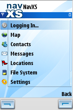
Java Clients v0.2.7 are online. This is mostly a cosmetic update, fixing a few missing icons etc. Also a sometimes occurring hang on shutdown has been fixed.

On another topic: I saw the new James Bond film a few days ago. Better then last few, but still not quite Connery… Anyway, on several occasions during the film I found my self thinking about NavXS, as our hero used his mobile phone to track down the bad guys and find his way to Casino Royal. Tom Cruise used similar solutions in Mission Impossible III. This clearly shows that science fiction is catching up on reality ;-)


Monday, November 20, 2006

It's been a while since last update, but here it is: version 0.2.6

So, what's new? Quite a bit actually! here's a short list:

  • Ta-da! A new main menu. Here a screenshot of how it looks on a Nokia. Hopefully it is easier to get around and find the right things now (let us know if it isn't).
  • NavXS elevation map tiles are supported (see previous post).
  • Users of the non-GPS editions (basic and jsr75) can now manually enter their location, which will be sent to their contacts. This options also exist in the full edition when automatic positioning is disabled. As of the next version we might make it so that you can see if the location of a contact has been entered manually or not, but as for now they are treated equally...
  • You can now define your own points of interest, or "Locations" as we call them (we're location based ;-). The locations are stored locally on your phone and you can use them to quickly position your map on some frequently used spot. In a sense, they're map bookmarks. What we haven't gotten around to do yet, but that will definitely come is the possibility to share your locations with your contacts an perhaps upload them to some searchable database, such as WikiMapia or equivalent (suggestions anyone?).
  • Latitudes and longitudes can now be displayed as degrees, minutes and seconds (e.g. 12° 20' 59.489"), rather than decimals only (12.34985805). Also you can configure whether you want to have distances and other values displayed in metric units (e.g. meters, km, km/h) or imperial units (e.g. feet, miles, mph)
  • Messages (both received and sent) are now stored locally on the phone.
  • File system cleanups are a bit less confusing...

Windows Mobile users: sorry the WinMobile equivalent is not quite there yet. It'll come as soon as Christoph gets around to it ;-)

- Helge -

Monday, November 06, 2006


Ok, this has not been much of a blog so far. And for the simple reason that we're busy working :-) Among other things, on our first set of map: An elevation map based on the NASA/USGS Shuttle Radar Topography Mission data (see http://srtm.usgs.gov/ for more info).

Covering the entire world between plus/minus 60 degrees latitude, and spanning zoom levels 0 to 10, it will look something like the image to the left (northern Italy and the Alps) when dsiplayed in the NavXS mobile client.

New mobile client versions are in progress. Release date: Suddenly!

- Helge -

Friday, October 06, 2006

New Blog from NavXS

Hello,

there is now the NavXS Blog for you.
Here we will post all new information about our project NavXS.com.
Moreover we post important information about software development for Smartphones, PocketPCs and other mobile devices.


Stay tuned!!

Christoph Langewisch